At Domu, we understand the importance of a smooth commute, so we've created an updated guide to help you navigate Chicago's traffic reports with ease. Whether you're a seasoned local or new to the city, our guide breaks down the jargon and fast-paced reporting to give you clear, actionable information. Learn about the latest changes in Chicago's expressways, discover tips to avoid bottlenecks, and stay informed with real-time updates on major traffic routes, including the Kennedy, Eisenhower, and Stevenson Expressways.
The local convention is to report the traffic from the northernmost expressway and then circle counter-clockwise around the city. Typically, the broadcast starts with a report on the Edens Expressway, then moves to the Kennedy, the Eisenhower, the Stevenson, and the Dan Ryan, in that order. The attention shifts to the Bishop Ford Freeway, the four tollways -- the Jane Addams, the Ronald Reagan, the Veterans Memorial, and Interstate 80/94 (the Borman) -- and, finally, Lake Shore Drive.
Though this is probably self-evident, in the interstate highway system, secondary highways that branch off of primary highways (typically to encircle a metropolitan area) are labeled with three digits. In contrast, primary highways are labeled with two. The extra digit in a secondary highway is the prefix to the two-digit number of the primary highway. For example, Interstate 94 is a primary highway leading from Indiana to Illinois to Wisconsin. At the same time, Interstate 294 (the Tri-State Tollway) is a secondary highway that branches off Interstate 94 near Indiana, encircles the Chicagoland suburbs, and rejoins Interstate 94 near O’Hare Airport.
The paragraphs below identify all the major highways and all the associated landmarks that we think you need to know to make sense of the local traffic reports.
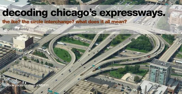
The Jane Byrne Interchange (aka, Circle or "The Spaghetti Bowl")
This squid-shaped knot of entrance and exit ramps is located a few blocks southwest of the Chicago Loop, where the Dan Ryan, the Kennedy, and the Eisenhower Expressways all converge. Virtually all traffic reports in Chicago mention this circular interchange at least once. The interchange began extensive renovations and renewals in the years following 2014, closing many of the exit and entrance ramps in the process. The improvements, completed in 2022, were meant to cure the interchange, named after Chicago's first female mayor, that was perennially considered one of the worst traffic bottlenecks in the country.
The Tri-State Tollway
The Tri-State Tollway (Interstate 294) branches off Interstate 94 just west of Munster. It meanders counter-clockwise through such suburbs as Markham, Midlothian, Hickory Hills, Willow Springs, Western Springs, Elmhurst, Schiller Park, Des Plaines, Glenview, and Northbrook before rejoining Interstate 94 between Deerfield and Riverwoods. (After they reunite, Interstate 94 continues as the Tri-State Tollway.) Between Schiller Park and Des Plaines, the Tri-State Tollway runs just east of O’Hare Airport. In its counter-clockwise path around the metropolitan area, the Tri-State Tollway crosses Interstate 57, Interstate 55 (the Stevenson), Interstate 88 (the Reagan), Interstate 290 (the Eisenhower), and Interstate 90 (the Jane Addams), making it a ubiquitous reference point in traffic reports.
The Mile Long Bridge
The Mile Long Bridge carries traffic on the Tri-State Tollway over the Desplaines River, just south of its intersection with Interstate 55, between Willow Springs and Burr Ridge. It underwent significant renovations completed in 2020 to improve structural integrity and traffic flow.
The Bensenville Bridge
The Bensenville Bridge carries traffic on the Tri-State Tollway over the sprawling, unsightly Metra rail yard and the adjacent Mannheim Road, due south of O’Hare Airport in Schiller Park. Recent updates have enhanced its safety and capacity.
"163rd Street Toll Plaza to the 83rd Street Toll Plaza"
Reports of traffic on the Tri-State Tollway may reference the travel times between the Toll Plaza at 163rd Street in Hazel Crest and the Toll Plaza at 83rd Street in Hickory Hills, 13.5 miles. Commuters who take this route will pass by Midlothian, Posen, Robbins, Crestwood, Chicago Ridge, and Palos Hills, among other southwest suburbs.
"The 83rd Street Toll Plaza to the Cermak Road Toll Plaza"
Reports of traffic on the Tri-State Tollway may reference the travel times between the 83rd Street Toll Plaza in Hickory Hills and the Cermak Road Toll Plaza in Oak Brook, 11.5 miles. Commuters who travel this path will pass through (or along) Burr Ridge, Willowbrook, and Hinsdale.
"The Cermak Toll Plaza to the Irving Park Road Toll Plaza"
Reports of traffic on the Tri-State Tollway may reference the travel times between the Cermak Road Toll Plaza in Oak Brook and the Irving Park Road Toll Plaza just south of O’Hare Airport, nine miles.
The Stevenson Expressway
The Stevenson Expressway (named for Illinois Governor Adlai Stevenson) consists solely of that 18-mile portion of Interstate 55 extending southwest from Lake Shore Drive in Chicago to County Line Road in Burr Ridge. The Stevenson runs adjacent and parallel to the south branch of the Chicago River. Drivers who ride the entire length of Interstate 55 ultimately pass through Springfield, St. Louis, Memphis, and New Orleans.
The Eisenhower Expressway (aka, the "Ike")
The Eisenhower Expressway (feel free to call it the "Ike”) splits west off Interstate 90 at the "circle interchange." It traverses nearly 30 miles through the western and northwestern suburbs before reuniting with Interstate 90 in Schaumburg. Inbound from Schaumburg, the Eisenhower runs southeast through Itasca and Addison, due south adjacent to the Tri-State Tollway, and east from Hillside to Bellwood to Maywood to Forest Park to Oak Park before reaching Chicago. A secondary roadway, the Ike has a three-digit moniker and is known as “Interstate 290.”
The Eisenhower Extension
Traffic reports often reference the “Eisenhower Extension.” This means the stretch of the Eisenhower Expressway extending between its point of contact with the Tri-State Tollway in Elmhurst (at North Avenue) to its point of merger with Interstate 355 near Wood Dale.
The Old Post Office
The Eisenhower Expressway begins as Ida B. Wells Drive (formerly Congress Parkway) and shoots outbound from underneath the old post office building downtown. For this reason, traffic reports often reference the travel time to the post office, which is shorthand for “downtown Chicago.”
The “Hillside Strangler”
In the old days, seven eastbound lanes from the Ronald Reagan Memorial Tollway, the Eisenhower Expressway, and the Tri-State Tollway converged into three lanes at Mannheim Road, creating a notorious traffic bottleneck near the Village of Hillside, hence the name “Hillside Strangler.” A highway widening project was completed in the early 2000s, although the term “Hillside Strangler” remains a part of the traffic lexicon to this day.
Route 53
Route 53 runs from Lake Cook Road (in Long Grove) to Interstate 355, contiguous (for only a brief stretch) with the Eisenhower Expressway. South of Biesterfield Road, Route 53 runs south of and parallel to the Eisenhower. Nonetheless, traffic reporters often use the phrase “Route 53” to refer to that portion of the Eisenhower Expressway that runs between Interstate 355 and the Jane Addams Tollway.
"Woodfield to the Old Post Office" | "Woodfield to the Circle"
A traffic report on the Eisenhower Expressway may be based on the travel time between Woodfield Mall in Schaumburg and the old post office or the circle interchange, a distance of 29.5 miles.
"Route 53 to the Old Post Office" | "53 to the Circle"
When a traffic report references the time from “Route 53 to the old post office” or “Route 53 to the circle,” it means the point where Route 53 intersects the Eisenhower at Biesterfield Road in Elk Grove Village to the point where the Eisenhower arrives downtown, a distance of 26.2 miles.
"Thorndale Avenue to the Old Post Office" | "Thorndale to the Circle"
A traffic report on the Eisenhower Expressway may be based on the travel time between Thorndale Avenue and the old post office or the circle interchange, a distance of 25.1 miles. Thorndale Avenue intersects the Eisenhower in Itasca.
"I-355 to the Old Post Office" | "355 to the Circle"
Traffic on the Eisenhower Expressway may be measured by the travel time between Interstate 355 (near Addison) and the old post office or the circle interchange, just over 23 miles.
"Wolf Avenue to the Old Post Office" | "Wolf to the Circle"
A traffic report on the Eisenhower Expressway may be based on the travel time between Wolf Road and the old post office or the circle interchange, a distance of 13.7 miles. Wolf Road intersects the Eisenhower Expressway in Hillside.
"Mannheim Road to the Old Post Office" | "Mannheim to the Circle"
Traffic on the Eisenhower Expressway may be gauged by the travel time between Mannheim Road and the old post office or the circle interchange, just over 12 miles.
The Kennedy Expressway
The Kennedy Expressway refers to a 17.8-mile stretch of highway from the circle interchange (at the Loop) to O’Hare Airport. The Kennedy Expressway, which runs northeast from the city, begins at a point where Interstate 90 (arriving from Boston) and Interstate 94 (arriving from Detroit) have already merged into a single highway (known as Interstate 90/94). About eight miles northeast of the Loop, the two interstates fork apart. At the split (or the "Junction,” depending on your perspective), drivers heading left continue on the Kennedy Expressway toward O’Hare Airport, while drivers heading north continue on the Edens Expressway and wind around toward the Tri-State Tollway, which leads to Milwaukee. Further outbound, the Kennedy Expressway becomes the Jane Addams Expressway shortly before crossing the Tri-State Tollway. Meanwhile, passengers traveling to O’Hare Airport remain on the Kennedy Expressway and exit on Interstate 190, the short spur that leads directly to the terminals.
"O’Hare to Downtown"
Commuters are sometimes informed of the travel time from “O’Hare to downtown.” This refers to the entire length of the Kennedy Expressway, from O’Hare Airport to the Loop.
"Montrose to Downtown"
The phrase “Montrose to downtown” refers to that stretch of the Kennedy Expressway extending from its junction with the Edens expressway to the circle interchange.
"Hubbard’s Cave"
Traffic reports frequently reference “Hubbard’s Cave,” which is the quarter-mile underground passage through which the Kennedy Expressway travels between Hubbard and Wayman streets. Technically, “Hubbard’s Cave” is not fully enclosed underneath the warehouses, parking lots, and railroad tracks above it. “Hubbard’s Cave” is another way of saying “downtown” for drivers heading south on the Kennedy Expressway.
Edens Expressway
Heading away from the city, the Edens Expressway begins when Interstate 90/94 splits in two. Drivers who veer left continue on the Kennedy Expressway (Interstate 90), while drivers who veer right continue on the Edens Expressway (Interstate 94). The Edens winds north until just past Dundee Road (between Glencoe and Northbrook), at which point it swerves west (the so-called Edens spur) to reunite with the Tri-State Tollway. The Edens was the first expressway in Chicago when it opened in December 1951.
"Lake Cook to the Junction" | "Lake Cook to Montrose"
Commuters are often told the travel time from “Lake Cook to the Junction.” “Lake Cook” refers to Lake Cook Road, which runs east-west on the line separating Lake and Cook counties. In traffic parlance, “Lake Cook” means the point intersection of Lake Cook Road and Route 41 (Skokie Highway), just north of the Edens spur. The "Junction” is the junction of the Edens Expressway and the Kennedy Expressway, just north of Cicero Street and Montrose Avenue in Chicago.
Dan Ryan Expressway
The Dan Ryan Expressway (named for a longtime Cook County commissioner) is the 14-lane behemoth that funnels traffic in and out of the circle interchange from the city's south side. Think of it as the south-side counterpart to the Kennedy Expressway. The initial 7.4-mile outbound stretch of the Dan Ryan (from the Loop to 66th Street) consists of merged Interstate 90/94, and the remaining 4.0-mile stretch consists exclusively of Interstate 94. At 95th Street, Interstate 57 sprouts off Interstate 94 and begins a journey to southern Illinois. After the split, Interstate 94 continues as the Bishop Ford Freeway.
"95th Street to Downtown" | "The Merge"
Traffic reports may use “95th Street” or “The Merge” as shorthand for the point where the Dan Ryan Expressway splits into the Bishop Ford Freeway and Interstate 57 on the far south side of Chicago.
Chicago Skyway
Once the Kennedy Expressway reaches the circle interchange, it becomes the Dan Ryan Expressway. At 66th Street, Interstate 90 splits from Interstate 94 and winds southeast toward Indiana before continuing to Cleveland, Buffalo, Boston, and many points. Between 66th Street and the Indiana state line, Interstate 90 is known as the “Chicago Skyway.” After it crosses the line, it becomes known as the “Indiana East-West Toll Road.”
The High Bridge
The High Bridge is a steel truss bridge that carries traffic on the Chicago Skyway over the Calumet River. It is the highest road in Chicago and should not be confused with the “Steel Bridge.”
Veterans Memorial Tollway | Interstate 355
The Veteran’s Memorial Tollway (also known as Interstate 355 and formerly known as the North-South Tollway) is the north-south highway in the far western suburbs that runs from Interstate 80 in New Lenox to the Eisenhower Extension (Interstate 290) in Itasca. It originally branched north off Interstate 55 (the Stevenson Expressway), which is how it earned its numerals, but was recently extended twelve miles south of the Stevenson Expressway. Veterans Memorial Tollway intersects the Stevenson Expressway between Lemont and Bolingbrook and slithers along and across the Ronald Reagan Memorial Tollway near Downer’s Grove.
"Boughton Road Toll Plaza to the Army Trail Toll Plaza"
Traffic reports for Veterans Memorial Tollway may reference the travel time between the Boughton Road Toll Plaza and the Army Trail Toll Plaza. The Boughton Road Toll Plaza is in Bolingbrook, about a half-mile north of Boughton Road, and the Army Trail Toll Plaza is in Addison, about a mile south of Army Trail Road. The distance between the two toll plazas is approximately 15.5 miles.
Jane Addams Tollway
The Jane Addams Tollway (formerly known as the “Northwest Tollway”) refers to Interstate 90 from the point that the Kennedy Expressway veers off toward O’Hare Airport until the point that it reaches the Wisconsin state line near Beloit. The Jane Addams Tollway heads northwest through Schaumburg, Rolling Meadows, Hoffmann Estates, South Barrington, Elgin, and Belvidere before making an abrupt northward turn just outside of Rockford.
"The Elgin Toll Plaza to Route 53"
Traffic reports sometimes reference the travel time between the Elgin Toll Plaza and Route 53. The Elgin Toll Plaza is on the Jane Addams Tollway about a mile northwest of Route 31 and about a mile-and-a-half southeast of Randall Road. Route 53 intersects the Jane Addams Tollway about 14.5 miles inbound from the Elgin Toll Plaza, between Schaumburg and Rolling Meadows, and about nine miles outbound from O’Hare Airport.
"Route 53 to the Kennedy"
Traffic on the Jane Addams Tollway may also be expressed as the travel time from Route 53 to the Kennedy Expressway, the nine-mile distance between Schaumburg and O’Hare Airport.
Bishop Ford Freeway
The Dan Ryan splits at 95th Street near Chicago State University, heading outbound from the city. One road becomes Interstate 57 and heads southwest toward St. Louis, while the other road continues as Interstate 94 but is now known as the “Bishop Ford Freeway.” The Bishop Ford (formerly known as the Calumet Expressway) runs southeast for ten miles until it reaches the Tri-State Tollway. Commuters from such suburbs as Dolton, Burnham, South Holland, Lansing, and Munster are likely to drive the Bishop Ford Freeway.
The Steel Bridge
The “Steel Bridge” carries Bishop Ford motorists over the Little Calumet River. It’s located about halfway between the Tri-State Tollway and the Dan Ryan Expressway.
Interstate 57
Interstate 57 is one of the few major roadways in the Chicagoland area that has not been named for someone famous. Traveling outbound, Interstate 57 begins as an offshoot of the Dan Ryan Expressway at 95th Street, then continues south. It passes near or through Morgan Park, Calumet Park, and Dixmoor before crossing the Tri-State Tollway. After that, it continues near or through Midlothian and Markham before reaching Interstate 80 near Country Club Hills.
Ronald Reagan Memorial Tollway
The Ronald Reagan Memorial Tollway (formerly known as the East-West Tollway) begins in the western suburbs by splitting off the Eisenhower Expressway shortly before the Eisenhower reaches the Tri-State Tollway. It continues westward, crossing Interstate 355 between Downer’s Grove and Lisle, and ultimately terminates 140 miles from where it started, just outside the Quad Cities, near the Iowa state line. Commuters on the Ronald Reagan Memorial Tollway likely live in such suburbs as Batavia, Aurora, and Naperville. Factoid enthusiasts will be thrilled to know that the Reagan Tollway is a completely intrastate, interstate highway. It is fully contained within the State of Illinois but was designated an interstate highway in 1987 to be exempt from speed limit restrictions. It was named after President Reagan shortly following his death in 2004 because it passes near his birthplace (in Tampico) and his boyhood home (in Dixon).
"The Aurora Toll Plaza to 290"
Traffic reports for the Ronald Reagan Memorial Tollway may refer to the inbound travel time from the Aurora Toll Plaza to Interstate 290 (the Eisenhower Expressway). The Aurora Toll Plaza is about half-mile inbound from the bridge over the Fox River. This is a 23-mile stretch.
"The Aurora Toll Plaza to the York Road Toll Plaza"
Traffic reports for the Ronald Reagan Memorial Tollway may also refer to the inbound travel time from the Aurora Toll Plaza to the York Road Toll Plaza near Oak Brook, just past Kingery Highway (Route 83). This is a 20.5-mile stretch.
Lake Cook Road
Lake Cook Road (also known as County Line Road) marks the border between Cook County and Lake County. Between Cook County and McHenry County, and finally, further westward, between McHenry County and Kane County before it terminates in Algonquin, just west of Barrington. Lake Cook Road passes near or through Palatine, Arlington Heights, Buffalo Grove, Riverwoods, Northbrook, Deerfield, Highland Park, and Glencoe on its eastward journey.
Elgin-O'Hare Expressway
The Elgin-O’Hare Expressway neither starts in Elgin nor ends at O’Hare. It runs mainly parallel to and south of the Jane Addams Memorial Tollway, and it serves as a route from the Eisenhower Expressway to Lake Street (Route 20). Outbound begins as Thorndale Road in Itasca, passes under the Eisenhower Extension, crosses Rohlwing Road (Route 53), and terminates at Lake Street in Hanover Park. The entire expressway extends less than six miles and has traffic lights at both ends, producing notorious rush-hour congestion.
Kingery Expressway
The Kingery Expressway (also known as 80/94) is the three-mile stretch of highway that extends from the Indiana State Line to the point where it splits into the Tri-State Tollway and the Bishop Ford Freeway. (It should not be confused with Kingery Highway in DuPage County.) Commuters who drive on the Kingery Expressway may live in such places as Lansing, Hammond, Munster, and Gary.
Table of Key Travel Times
| Highway | From | To | Distance (miles) |
|---|---|---|---|
| Tri-State Tollway | 163rd Street Toll Plaza | 83rd Street Toll Plaza | 13.5 |
| Tri-State Tollway | 83rd Street Toll Plaza | Cermak Road Toll Plaza | 11.5 |
| Tri-State Tollway | Cermak Road Toll Plaza | Irving Park Road Toll Plaza | 9 |
| Eisenhower Expressway | Woodfield Mall | Old Post Office/Circle Interchange | 29.5 |
| Eisenhower Expressway | Route 53 | Old Post Office/Circle Interchange | 26.2 |
| Eisenhower Expressway | Thorndale Avenue | Old Post Office/Circle Interchange | 25.1 |
| Eisenhower Expressway | I-355 | Old Post Office/Circle Interchange | 23 |
| Ronald Reagan Memorial Tollway | Aurora Toll Plaza | Interstate 290 (Eisenhower Expressway) | 23 |
| Ronald Reagan Memorial Tollway | Aurora Toll Plaza | York Road Toll Plaza | 20.5 |
Rush Hour vs. Peak Travel Times
| Highway | From | To | Rush Hour (mins) | Peak (mins) | Direction |
|---|---|---|---|---|---|
| Tri-State Tollway | 163rd Street Toll Plaza | 83rd Street Toll Plaza | 20 | 30 | Inbound |
| Tri-State Tollway | 83rd Street Toll Plaza | Cermak Road Toll Plaza | 15 | 25 | Inbound |
| Tri-State Tollway | Cermak Road Toll Plaza | Irving Park Road Toll Plaza | 12 | 20 | Inbound |
| Eisenhower Expressway | Woodfield Mall | Old Post Office/Circle Interchange | 35 | 50 | Inbound |
| Eisenhower Expressway | Route 53 | Old Post Office/Circle Interchange | 30 | 45 | Inbound |
| Eisenhower Expressway | Thorndale Avenue | Old Post Office/Circle Interchange | 28 | 40 | Inbound |
| Eisenhower Expressway | I-355 | Old Post Office/Circle Interchange | 25 | 35 | Inbound |
| Ronald Reagan Memorial Tollway | Aurora Toll Plaza | Interstate 290 (Eisenhower Expressway) | 25 | 35 | Inbound |
| Ronald Reagan Memorial Tollway | Aurora Toll Plaza | York Road Toll Plaza | 23 | 30 | Inbound |
Test Yourself
Take this quiz to see how well you know Chicago's traffic reports and expressways!
- What is the name of the interchange where the Dan Ryan, Kennedy, and Eisenhower Expressways converge?
- Which expressway is referred to as "The Ike"?
- What is the distance between the Aurora Toll Plaza and Interstate 290 on the Ronald Reagan Memorial Tollway?
- Which expressway is known for the "Hubbard’s Cave" section?
- What are the primary highways mentioned in the local traffic reporting conventions?